Sanborn fire insurance maps of Missouri collection.
Creator
Title
Sanborn fire insurance maps of Missouri collection.
Publisher
Sanborn Maps Company
Date
1883-1992.
Extent
1283 maps (10,351 sheets)
Description
History
The Sanborn Fire Insurance Map Company, established in 1867, compiled and published maps of U.S. cities and towns for the fire insurance industry to assess fire risk.
Scope and Contents
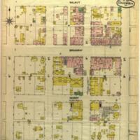
Documenting the layout of 390 Missouri cities from 1883 to 1951, the 1,283 maps in the collection are an invaluable research tool for urban historians, architectural historians, environmentalists, genealogists and preservationists.
Their large scale (1:600) offers detailed information on the use made of commercial and industrial buildings, their size, shape and construction material. Some residential areas are also mapped. The maps show the location of water mains, fire alarms and fire hydrants. They are color-coded to identify the structure (adobe, frame, brick, stone, iron) of each building.
Microfiche copies of the maps are also available.
Commercially prepared microfilm of maps for 55 Missouri cities dating from 1941-1992 supplement the collection.
Table Of Contents
Finding aid: Sanborn Maps of Missouri Collection
Has Format
MU Digital Library: Sanborn Maps of Missouri.
See also Sanborn Maps at the Library of Congress.
Relation
While most of the Sanborn maps have keys, the University of Virginia Libraries compiled a very useful guide to interpreting the symbols and colors used on the maps.
Identifier
Catalog: Sanborn fire insurance maps of Missouri collection.
Note: Items in collection are cataloged separately.
Note: Items in collection are cataloged separately.
OCLC/WorldCat Number: 709782452
Subject
Provenance
Between 1955 and 1978, the Library of Congress withdrew duplicate sheets and atlases from their collection and offered them to selected libraries. Maps for Missouri towns and cities were given to the MU Libraries.
Rights
Some maps in the collection are under copyright restriction. Please contact Environmental Data Resources, Inc. if you wish to order complete copies of Sanborn maps, or contact us to make other arrangements.
Access Rights
Materials do not circulate but are available to users in the Special Collections Reading Room during service hours or by appointment.
Format
Maps.
Language
English
Type
Publication Type: Book
Document Type: Non-fiction
Document Type: Non-fiction